Remote Sensing and Aerial Surveying in the UAE: Market Dynamics, Technological Development, and Applied Innovations
-
Artem Petrochenko
KazAeroSpace LLP, Astana, Kazakhstan
Aidana Rakhimova
KazAeroSpace LLP, Astana, Kazakhstan
| Received 01 May, 2025 |
Accepted 01 Jul, 2025 |
Published 02 Jul, 2025 |
The growing integration of geospatial technologies, particularly aerial surveying and remote sensing, plays a pivotal role in the development of the United Arab Emirates (UAE) across various sectors, including urban planning, agriculture, energy, environmental protection, and national security. This paper explores the current market trends, technological advancements, and practical implementation of airborne surveying systems in the UAE, focusing on both manned and unmanned aerial platforms. The study also introduces a patented hybrid hardware-software system designed for high-precision aerial mapping and photogrammetry. Based on comparative analysis, this system offers significant advantages in cost-efficiency and operational speed over traditional UAV-based and satellite imaging methods. The results highlight the UAE’s strategic positioning within the MENA region as both a consumer and innovator in the field of geospatial intelligence.
The UAE’s focus on digital transformation, urban growth, and infrastructure investment has made it a regional leader in geospatial technologies. Advanced aerial survey systems, especially hybrid stabilized platforms, offer clear advantages over traditional methods in cost, speed, and flexibility. Their use in both public and private sectors supports rising demand for detailed spatial data and strengthens the UAE’s role as an emerging exporter of remote sensing technology. Ongoing advances in stabilization, data processing, and AI are expected to further expand the potential of aerial mapping shortly.
| Copyright © 2025 Petrochenko and Rakhimova. This is an open-access article distributed under the Creative Commons Attribution License, which permits unrestricted use, distribution, and reproduction in any medium, provided the original work is properly cited. |
INTRODUCTION
Aerial photography and remote sensing technologies, employing both Unmanned Aerial Vehicles (UAVs) and manned aircraft, have become essential tools across various sectors in the UAE, including urban development, agriculture, oil and gas exploration, environmental monitoring, and security and defense. The growing global trend of integrating geospatial data management and deep learning methods to enhance the accuracy and efficiency of spatial analyses derived from aerial platforms. The UAE’s unique combination of dense urban environments, climatic variability, and ambitious infrastructure projects positions it as a strategic hub for the adoption and advancement of these technologies within the MENA region.
Aligned with the nation’s digital transformation agenda, the government has prioritized smart city initiatives, land-use monitoring, and the sustainable management of natural resources throughout the 2020s. This has substantially increased the demand for high-precision cartographic data and advanced geospatial analytics. However, challenges remain in effectively integrating UAV and remote sensing data within complex urban and environmental contexts, highlighting a gap in current methodologies1,2.
This study aims to address these challenges by developing and validating novel approaches that leverage UAV-based aerial imagery and advanced data processing techniques to improve geospatial data accuracy and application in the UAE. By doing so, it seeks to contribute new insights and practical solutions that support ongoing national digital and smart infrastructure strategies.
Market overview: The UAE’s aerial surveying market is closely tied to its rapidly evolving geospatial sector. According to market research:
| • | The geospatial solutions market, including aerial imaging and terrain analysis, is projected to reach USD 26.3 billion by 2030, with a Compound Annual Growth Rate (CAGR) of 15.7% from 2025 to 2030 | |
| • | The geospatial analytics market is expected to reach USD 470 million by 2030, with a CAGR of 7.76% over the same period |
Figure 1 illustrate a growing demand for geospatial technologies and innovative aerial data acquisition systems within the UAE2.
Technological advancements and system design: Aerial surveying forms a core element of modern remote sensing systems, supporting object monitoring, infrastructure inspection, and large-scale mapping. Technological progress in this domain is driven by the use of both UAVs and piloted aircraft equipped with various imaging systems. These platforms enable efficient and automated data collection across extensive areas, benefiting sectors such as environmental monitoring, agriculture, and geodesy.
Despite the advantages of UAVs, several operational constraints persist regulatory requirements for flight permissions, particularly in urban or border zones; weather sensitivity (wind, precipitation, temperature); high operational costs (maintenance, battery replacement, pilot training); and limited flight duration and range.
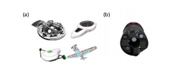
To address these limitations, an alternative system has been developed and patented-a hybrid hardware-software complex for aerial mapping and photogrammetry. This system includes a flight platform, imaging device, gyro stabilized gimbal, geolocation tools, and a software suite for image processing and spatial data analysis.
|
System features and innovation: The primary technical advantage of this system lies in its stabilization architecture. A gyroscope is mounted on a gimbal with two-axis rotational freedom, ensuring consistent orientation during flight. The structure is optimized for spatial precision and minimal drift.
Further innovation includes: Stepper motors at the gimbal joints enabling electronic stabilization; reduced form factor and enhanced horizontal stability, even with heavier payloads; compatibility with various aerial vehicles and imaging equipment, including ultra-high-resolution cameras, thermal sensors, and LiDAR units.
This versatility allows the system to serve multiple purposes: Geological surveying, mineral exploration, topographic mapping, and civil monitoring.
Limitations of single-camera systems and the shift to multi-camera platforms: Traditional aerial photography has historically relied on single-camera configurations, which, while capable of producing high-resolution imagery, are subject to inherent limitations. Chief among these is their restricted field of view, which necessitates longer flight durations and extended data acquisition periods. This constraint poses significant inefficiencies, particularly in the context of large-scale aerial surveys, where operational efficiency and spatial coverage are critical for cost-effective and timely data collection.
In response to these constraints, multi-camera systems have emerged as a substantial innovation within the domain of aerial imaging. By deploying multiple cameras to capture images concurrently, these systems significantly reduce acquisition time while enhancing spatial coverage. This capability is especially advantageous in applications such as topographic mapping, precision agriculture, and environmental monitoring, where both wide-area coverage and high spatial resolution are essential. Furthermore, the simultaneous acquisition of images from varying perspectives contributes to improved photogrammetric outputs, particularly in the generation of orthophotos, leading to more accurate, and reliable geospatial datasets3.
A representative example of such technology is the Leica RCD30 Penta system, which integrates five cameras into a unified platform to enhance both the precision and productivity of aerial surveys. Through high-resolution imaging and advanced synchronization mechanisms, the RCD30 Penta offers clear advantages over conventional single-camera systems. Its ability to acquire imagery from multiple viewpoints concurrently enables the production of more detailed and geometrically accurate orthophotos, supporting applications in urban development, infrastructure planning and environmental assessment4.
In addition to the RCD30 Penta, Leica has developed other advanced imaging systems, such as the Leica Aibotix UAV platform. Designed for UAV-based aerial surveys, these systems integrate multi-camera configurations with various sensors to facilitate precise and efficient aerial mapping. Such UAV-based solutions are particularly suitable for small-scale projects or operations in areas that are inaccessible to traditional manned aircraft.
Despite these advancements, several technical challenges remain. One of the most prominent is the issue of camera synchronization. Ensuring temporal and spatial alignment across multiple cameras is essential to avoid geometric inconsistencies and image distortion, challenges that are exacerbated by platform motion, fluctuations in altitude, and variations in airspeed. These factors can induce subtle shifts in camera orientation, adversely affecting the spatial coherence of the captured imagery.
The company has engineered an innovative hardware-software complex equipped with a gyrostabilization mechanism, specifically designed for aerial photography applications in Fig. 1. The system is adaptable for integration with a wide range of aircraft platforms, requiring no structural modifications to the airframe.
| Table 1: | Comparative analysis of different aerial imaging tools | |||
| System | Cost per km² | Image resolution | Flight altitude | Time to completion |
| Hybrid hardware-software complex | 35$ | Up to 10 cm/pixel | 1000 m | 5 working days |
| Satellite imaging | 45$ | 30 cm/pixel | 6000 m | 5 working days |
| UAV(Drone) | 135$ | Up to 10 cm/pixel | 150-500 m | 168 working days |
| Table 2: | Comparison of multi-camera systems and a gyrostabilized system | |||
| Feature | Our complex | Leica RCD30 | Leica RCD30 Penta | Leica aerial systems |
| Resolution per camera | 151 Mp | up to 60 Mp | up to 60 Mp | up to 80 Mp |
| Number of cameras | 5 (downward+4 directions) |
single or multicamera |
5 (downward+4 directions) |
Varying configuration |
| Stabilization | advanced stabilization+ gyro stabilization system |
basic stabilization |
standard stabilization |
basic stabilization |
| Flight altitude | up to 3000 m | up to 3000 m | up to 3000 m | up to 3000 m |
| System installation | can be installed on any aircraft | specific requirements | specific requirements | specific requirements |
The complex incorporates five high-resolution digital cameras, each strategically positioned to fulfill a distinct function in the image acquisition process. One camera is oriented vertically downward, while the remaining four are directed forward, backward, and laterally (left and right) in alignment with the aircraft’s flight path. This spatial configuration enables the simultaneous capture of five distinct images with minimal overlap, thereby enhancing both efficiency and spatial coverage during aerial surveys5.
Comparative performance analysis: Table 1 presents a comparative analysis of different aerial imaging tools for surveying a 1300 km² area (equivalent to a 20 km radius):
According to this data, the proposed system performs 33 times faster and 4 times cheaper than conventional UAV-based methods for equivalent image resolution, demonstrating clear economic and operational advantages.
Leica Geosystems is one of the leading manufacturers of aerial imaging systems, with several multi-camera solutions designed for different mapping and surveying needs. In addition to the Leica RCD30 Penta, Leica offers other multi-camera systems, such as the Leica RCD30 and Leica Aerial Systems, which are widely used in the industry for high-resolution mapping and aerial surveying6.
Table 2 presents a comparative analysis of features of multi-camera systems and a gyrostabilized system.
The comparison illustrates that while existing systems like the Leica RCD30 series offer strong performance, our patented solution stands out due to its integrated gyrostabilization, significantly higher image resolution, universal aircraft compatibility, and superior accuracy. These features collectively enhance data quality and operational efficiency, making it a highly effective tool for precision aerial surveying.
CONCLUSION
The UAE’s proactive digital transformation strategy, combined with rapid urbanization and strategic infrastructure investment, positions it as a leading hub for geospatial innovation in the Middle East. The implementation of advanced aerial surveying systems-particularly hybrid, stabilized platforms-offers a significant improvement over traditional UAV and satellite solutions in terms of cost, speed, and adaptability. The integration of such systems into commercial and government operations not only meets the growing domestic demand for high-resolution spatial data but also contributes to the UAE's emergence as a technological exporter in the field of remote sensing. Further research and development in stabilization technologies, data processing algorithms, and AI-based analytics will likely enhance the capabilities and applications of aerial surveying in the years ahead.
SIGNIFICANCE STATEMENT
Understanding what the land looks like from above is essential for smart city planning, farming, energy management, environmental protection, and national safety. This study looks at how the United Arab Emirates is using new flying technologies, like drones and small aircraft, to take detailed pictures of the land and how that helps in many areas of development. The research highlights a new system that uses both equipment and software to make these surveys faster, cheaper, and more accurate than older methods. This system can be used on different types of aircraft and provides high-quality images while flying. The results show that the United Arab Emirates is not only using these tools to support its growth, but is also becoming a leader in this field in the Middle East. By using advanced flying systems that are stable and efficient, the country can make better decisions, save money, and even share its knowledge with other countries. This kind of technology will be even more useful in the future as better ways to process and understand the data are developed.
REFERENCES
- El Hoummaidi, L., A. Larabi and K. Alam, 2024. Using Unmanned Aerial Systems and Deep Learning for Agriculture Mapping in Dubai Emirate. In: Drones-Various Applications, Cvetković, D. (Ed.), IntechOpen, London, England, ISBN: 978-0-85466-163-3.
- Breunig, M., P.E. Bradley, M. Jahn, P. Kuper and N. Mazroob et al., 2020. Geospatial data management research: Progress and future directions. ISPRS Int. J. Geo-Inf., 9.
- Tan, L. and H. Wu, 2024. Artificial intelligence mangrove monitoring system based on deep learning and sentinel-2 satellite data in the UAE (2017-2024). arXiv (Preprint).
- Colomina, I. and P. Molina, 2014. Unmanned aerial systems for photogrammetry and remote sensing: A review. ISPRS J. Photogramm. Remote Sens., 92: 79-97.
- Hammoudi, K. and J.M. Donald, 2013. Design, implementation and simulation of an experimental multi-camera imaging system for terrestrial and multi-purpose mobile mapping platforms: A case study. Appl. Mech. Mater., 332: 139-144.
- Feng, Y.P. and T.Z. Zheng, 2013. New technology of surveying and mapping in the application of deformation monitoring. Appl. Mech. Mater., 333-335: 1492-1495.
How to Cite this paper?
APA-7 Style
Petrochenko,
A., Rakhimova,
A. (2025). Remote Sensing and Aerial Surveying in the UAE: Market Dynamics, Technological Development, and Applied Innovations. Asian Journal of Earth Sciences, 18(1), 1-5. https://doi.org/10.3923/ajes.2025.01.05
ACS Style
Petrochenko,
A.; Rakhimova,
A. Remote Sensing and Aerial Surveying in the UAE: Market Dynamics, Technological Development, and Applied Innovations. Asian J. Earth Sci 2025, 18, 1-5. https://doi.org/10.3923/ajes.2025.01.05
AMA Style
Petrochenko
A, Rakhimova
A. Remote Sensing and Aerial Surveying in the UAE: Market Dynamics, Technological Development, and Applied Innovations. Asian Journal of Earth Sciences. 2025; 18(1): 1-5. https://doi.org/10.3923/ajes.2025.01.05
Chicago/Turabian Style
Petrochenko, Artem, and Aidana Rakhimova.
2025. "Remote Sensing and Aerial Surveying in the UAE: Market Dynamics, Technological Development, and Applied Innovations" Asian Journal of Earth Sciences 18, no. 1: 1-5. https://doi.org/10.3923/ajes.2025.01.05

This work is licensed under a Creative Commons Attribution 4.0 International License.